Helenair.com - Full Article
ROB CHANEY rchaney@missoulian.com
December 20 2016
MISSOULA -- Mountain bikers and wilderness advocates have forged an agreement that could create a new riding area on the edge of the Bob Marshall Wilderness while advancing an 80,000-acre expansion of nonmechanized public land.
The Blackfoot Clearwater Stewardship Project and International Mountain Bike Association committed to supporting each other’s wishes on what could become a stand-alone wilderness bill going before Congress next year. The deal modifies a wilderness proposal first introduced as part of Sen. Jon Tester’s Forest Jobs and Recreation Act in 2009.
It extends the southwestern edge of the Bob Marshall and Scapegoat wildernesses from the mountain ridgelines into the lower drainages where much of the area’s wildlife habitat and travel corridors exist.
“This compromise was more difficult than anything I remember,” said Lee Bowman, a BCSP steering committee member with the Montana Wilderness Association. “What really impressed me was how respectful the mountain bikers were of the horsemen’s issues. The horsemen weren’t in favor of this, but eventually they decided it was better for all. Nobody got everything they wanted. Everyone had to give up something.”
The 3,000-acre proposed mountain-biking recreation area extends along the Spread Creek drainage north of Ovando in a recommended wilderness area of the Lolo National Forest. Because the whole area remains in a management gray area regarding mechanized use, some mountain bikers had begun to chart routes along trails traditionally used by backcountry horse packers...
Read more here:
http://helenair.com/news/state-and-regional/bikers-hikers-reach-deal-on-bob-marshall-expansion-and-access/article_8d3d5863-7e65-5aac-82a6-d07c26f00aee.html
Tuesday, December 20, 2016
Monday, December 19, 2016
Celebrating 25 years of the Recreational Trails Program
 Equestrian Volunteers working on the Dolan Springs Trail System, Arizona
Americantrails.org
December 2016 marks the 25th anniversary of the law that created the Recreational Trails Program (RTP), one of the most important sources of funding for trail projects. Through all the years of competition for Federal dollars, the program has been continued helping States, volunteer groups, and project sponsors to improve our nationwide system of trails.
Since 1991, the RTP has provided more than $1 billion in Federal funding and has become the foundation for state trail programs across the country. It leverages hundreds of millions of dollars of additional support from other sources for trails, encourages productive cooperation among trail users, and facilitates healthy outdoor recreation and economic activity in countless communities.
RTP applies the “user-pay/user-benefit” philosophy of the Highway Trust Fund, returning federal tax on fuel used for nonhighway recreation to the states for trail projects. Program implementation is consistent in practice with other expenditures from the Highway Trust Fund. Although the gas tax supporting the Fund is paid primarily by gas-using vehicles, resources are shared with other users of recreational trails to develop a balanced system.
Project categories eligible for funding are many and varied, giving states the flexibility they need to administer state trail programs. State administrative and educational program costs are capped at 7% and 5% respectively. States are encouraged to work with qualified youth conservation or service corps.
Eligible types of projects include:
- maintenance and restoration of existing recreational trails;
-development and rehabilitation of trailside and trailhead facilities and trail linkages for recreational trails;
- purchase and lease of recreational trail construction and maintenance equipment;
- construction of new recreational trails (with specific requirements when federal land is involved);
- acquisition of easements and fee simple title for recreational trail corridors;
- and assessment of trail conditions.
Thirty percent of funds are to be spent for uses relating to motorized recreation; 30% are to be spent for uses relating to nonmotorized recreation. In addition, 40% are to be used for projects that facilitate diverse recreational trail use within a recreational trail corridor, trailside or trailhead.
After 25 years, RTP funding has grown to represent a larger portion of the total fuel taxes paid by nonhighway recreationists, although it is conservatively estimated that the RTP receives less than one-third of the total taxes paid annually by nonhighway recreationists. During Fiscal Year 2009, states received slightly more than $84 million in RTP funds, the same annual maximum approved under current federal funding authorization.
The Recreational Trails Program was created by the Intermodal Surface Transportation Efficiency Act of 1991 (ISTEA), reauthorized in 1998 as part of the Transportation Equity Act for the 21st Century (TEA-21) and again in 2005 through the Safe, Accountable, Flexible, Efficient Transportation Equity Act: A Legacy for Users (SAFETEA-LU).
The RTP was also included in the 2012 transportation-reauthorization bill, Moving Ahead for Progress in the 21st Century Act (MAP-21). Most recently, the RTP was reauthorized as part of the Fixing America’s Surface Transportation (FAST) Act, which covers Fiscal Years 2016 through 2020 and was signed by the President on December 5, 2015.
As was the case under MAP-21, under the FAST Act, funds are to be allocated to the states in the same amounts and according to the same allocations that were in place in Fiscal Year 2009, the last year of SAFETEA-LU. At that time, the formula apportioned half of all funding to the states equally and the remaining 50% was apportioned among eligible states based upon nonhighway recreational fuel use in each of those states during the preceding year. There have been no adjustments to those allocations since 2009.
Each year the Coalition for Recreational Trails, a federation of national and regional trail-related organizations, sponsors an awards program to recognize outstanding trail projects funded by the RTP. The awards are presented in Washington, DC as part of the Coalition’s ongoing effort to build awareness and appreciation of this highly successful program.
For more information...
Visit the database of over 21,000 RTP-funded projects: www.recreationaltrailsinfo.org
See details of the RTP, including funding for each State: www.fhwa.dot.gov/environment/recreational_trails
Annual awards from the Coalition for Recreational Trails: www.americantrails.org/awards/CRT-awards-by-state.html
Thursday, December 15, 2016
Opening Marin trail to bikes should include follow-up review
Marinij.com - Full Article
Marin IJ Editorial: Opening trail should include follow-up review
Marin’s open space trails have become a political battleground pitting bicycle access against safety.
Opening a half-mile trail to bike riders has turned the Alto Bowl open space between Mill Valley and Corte Madera into the latest battlefield.
The county Open Space District, which has made opening so-called “connector trails” to bikes a priority, has decided the Bob Middagh Trail fits that designation.
It provides a link for bike riders to reach fire roads and bike-approved trails on Mount Tamalpais.
The county is also planning to spend an estimated $25,000 on safety improvements along the half-mile trail.
But that has not quelled the criticism the plan is garnering from hikers and equestrians who see sharing the trail with bike riders to be a safety problem and “an intense use” that distracts from the enjoyment of using the tree-lined trail...
Read more here:
http://www.marinij.com/opinion/20161214/marin-ij-editorial-opening-trail-should-include-follow-up-review
Wednesday, December 14, 2016
Oregon Governor Calls For A 'Plan B' For The Elliott State Forest

OPB.org - Full Article
by Cassandra Profita Follow OPB/EarthFix | Dec. 13, 2016
Gov. Kate Brown on Tuesday sought an new alternative to selling a state forest in southwest Oregon to the only bidder to offer the full asking price.
At a meeting of the Oregon State Land Board, Brown called for setting aside $100 million in state bonding authority to allow for a new proposal on how the state should manage the Elliott State Forest going forward.
Brown thanked the sole bidder in the state’s effort to sell the Elliott State Forest before asking Oregon Department of State Lands Director Jim Paul to proceed with developing a direct offer of sale to Lone Rock Timber of Roseburg and the Cow Creek Band of the Umpqua Indians. The timber company and tribe submitted the only bid of $220.8 million for the 84,000-acre forest.
The governor also said she wants the land board to have another option on the table at its next meeting in February. She called on the public to work out a “Plan B” that would use up to $100 million in state bonds to buy the Elliott out of the Common School Fund and into a new ownership structure that could include state and private ownership.
“We are very clear that in Oregon our public lands are irreplaceable assets,” she said. “I absolutely believe we must protect the values we as Oregonians hold so dear...”
Read more here:
http://www.opb.org/news/article/elliott-state-forest-oregon-sale-plan/
Sunday, December 11, 2016
West Region: Horse Trailheads by Robert Sydnor
For members of the West Region of the American Endurance Ride Conference, I have prepared 71+ trailhead reports that you can download (for free) and use for conditioning your endurance horse.
These reports are in stable Adobe Acrobat .pdf format, and are typically about 3 pages long. All 71 reports are posted on my GoogleGroups website. This is *not* a blog site, since none of us AERC riders have time for that. My scholarly reports contain *no* advertising (since I am a geologist, not a businessman). AERC Trails Manager Monica Chapman suggested that I post the hyperlink here on the AERC Facebook page. This has taken me six years to write these AERC trailhead reports, and new reports appear each month.
These trailheads are mostly in Placer County, El Dorado County, Sacramento County, Nevada County, with several other reports at Yosemite National Park, Point Reyes, and the San Francisco Bay region. Emphasis is on the highway location of the trailhead and the logistics at that particular trailhead (road maps, gates, fee for usage, horse water (or not), and so forth.
This is not about the trails themselves, and the emphasis is how to find the trailhead and what conditions to expect. So I use lots of photographs of the horse assembly area. That way, nobody is disappointed about what to expect. Recall the aphorism that "A picture is worth a thousand words".....and this is certainly true for us AERC riders. That way, with lots of photographs, there are no adverse surprises when you arrive with a loaded horse trailer.
I want to encourage other AERC Trail Masters and AERC Ride Mangers to also create their own Google Groups website with hundreds of horse trailheads described for other AERC Regions across America. That way we can promulgate more riders to become members of AERC and join us. We want to be inviting to regular trail riders. Case in point: There are 14,283 persons at this website, but only about one-quarter of them are dues-paying members of AERC. We want our AERC membership to grow and to show "value-added" for actual membership.
Here is my trailhead website for AERC West Region:
Horse Trails by Robert H. Sydnor, Geologist https://groups.google.com/forum/#!forum/horsetrails
Respectfully submitted, Robert Hadley Sydnor, AERC Trail Master, AERC Statewide Horsetrails Advocate for California, and Geologist.
Thursday, December 8, 2016
BLM Gets Locals More Involved in Public Land Management
Ammoland.com - Full Article
Posted on December 5, 2016 by Ammoland Editor Joe Evans
WASHINGTON, D.C. -(Ammoland.com)- The Bureau of Land Management, which is responsible for overseeing 245 million acres of the nation’s public lands, has issued its final ‘Planning 2.0’ rule that will update how the agency plans for land management in the West.
The most significant change is the establishment of three additional public input periods early in the planning process to increase transparency and allow for more robust public involvement.
Sportsmen and women are hopeful that these changes will increase public satisfaction in the land-use planning process and eventual management of public lands...
Read more: http://www.ammoland.com/2016/12/blm-gets-locals-involved-public-land-management/#ixzz4SGgvOIZt
Wednesday, December 7, 2016
Marin hikers, equestrians dismayed over bike access on Alto Bowl trail
Marinij.com - Full Article
By Adrian Rodriguez, Marin Independent Journal
POSTED: 12/05/16
A plan to allow mountain bikers access to a short trail through the Alto Bowl Open Space Preserve in Mill Valley is causing consternation among hikers and equestrians who fear it will become a destination for cyclists and unsafe for other users.
The Marin County Open Space District announced last week it was moving forward with a proposal by the Marin County Bicycle Coalition to open up the less than half-mile Bob Middagh Trail to cyclists. The approximately $25,000 project is part of the road and trails management plan that the parks district adopted in 2014.
Hikers and equestrians who oppose the project say mountain biking is “an intense use” that is not a good fit for the neighborhood trail, which has historically been a calm, peaceful link to Mount Tamalpais and preserves west of Horse Hill.
“We don’t want to have to be on high alert all the time,” said Amory Willis, president of the Alto Bowl Horseowners Association, who said hikers, bikers and horseback riders have happily coexisted on fire roads and other paths. “It’s great, but not here...”
Read more here:
http://www.marinij.com/environment-and-nature/20161205/marin-hikers-equestrians-dismayed-over-bike-access-on-alto-bowl-trail
Tuesday, December 6, 2016
New enthusiasm leads to partnership on city trails
Duluthnewstribune.com - Full Article
By Lisa Kaczke on Dec 4, 2016
New trails in Duluth's St. Louis River corridor are in various stages of completion, with some still in the planning stage and others ready for use by residents and tourists alike.
The city's rollout of the trails in the river corridor since last year has been met with enthusiasm from outdoor sports groups, who see it as an opportunity to boost new interest in their activity — whether it's cross-country skiing, riding horses, paddling or mountain biking.
The city of Duluth is partnering with groups, including COGGS (Cyclists of Gitchee Gummi Shores), the Duluth Area Horse Trail Alliance and the Duluth Cross-Country Ski Club, to invest more money than the city can provide on its own. Additionally, "really strong relationships with community partner organizations" are a major component of ensuring the completed trails are maintained long-term, said Andrew Slade, assistant manager of Duluth's Parks and Recreation Division...
Read more here:
http://www.duluthnewstribune.com/news/4172375-new-enthusiasm-leads-partnership-city-trails
Thursday, December 1, 2016
Continental Divide Trail Coalition
Only about two hundred people a year attempt to hike the entire trail, taking about six months to complete it. Dave Odell thru-hiked in 1977 and in the same year Dan Torpey hiked from the NM/CO border to Mt Robson, Canada. German long-distance rider Günter Wamser (on his way from Tierra del Fuego to Alaska), and Austrian Sonja Endlweber (who joined him for the rest of the journey from Mexico) managed to complete the tour with four Bureau of Land Management mustangs in three summers 2007–09.
"One of the largest conservation efforts in the history of the United States"
The Continental Divide National Scenic Trail (CDT) is much more than just a line on a map: it is a living museum of the American West, a place to reconnect with nature, and a unifying force bringing people of all walks of life together.
The Continental Divide Trail Coalition (CDTC) is the 501 (c) (3) national non-profit working in partnership with the US Forest Service, National Park Service, and Bureau of Land Management to protect, promote, and preserve the Continental Divide Trail. CDTC is a membership organization founded by a group of citizens passionate about the CDNST and working to building a strong community of supporters and Trail Enthusiasts who want to see the Trail completed and protected, not just for today’s users, but for future generations to come.
CDTC recognizes the Trail belongs to the American Public and that we have a responsibility to future generations to responsibly manage the Trail’s resources and to place those resources in a sacred trust that will ensure the Trail continues to nurture others the way it has nurtured us.
To that end, CDTC is committed to building a non-motorized backcountry Trail and protecting the Trail corridor along the Continental Divide. CDTC serves the Trail through on the ground projects that ensure the Trail is maintained and its corridor is protected in perpetuity. This is accomplished through advocacy efforts for the Trail with agencies, law makers and the general public; supporting, and inspiring volunteerism for Trail construction and maintenance; communicating the vision and direction of the Trail as a sustainable resource; educating users, volunteers and the general public on the appropriate route and uses of the Trail; cultivating strong partnerships; fundraising to help leverage resources and widen our impact to protect and preserve the CDT; and by encouraging and supporting land protection efforts to acquire the acquisition of the Corridor on private lands to solve some of the Trail’s most challenging connectivity issues.
The Continental Divide National Scenic Trail (CDNST) was designated by Congress in 1978 as a unit of the National Trails System. The 3,100 mile CDNST traverses the magnificent Continental Divide between Mexico and Canada. It travels through 25 National Forests, 21 Wilderness areas, 3 National Parks, 1 National Monument, 8 BLM resource areas and through the states of Montana, Idaho, Wyoming, Colorado and New Mexico. The vision for the Continental Divide National Scenic Trail is to create a primitive and challenging backcountry trail on or near the Continental Divide to provide people with the opportunity to experience the unique and incredibly scenic qualities of the area. For many of the same reasons National Parks are established, National Scenic Trails are created to conserve the nationally significant scenic, historic, natural and cultural qualities of the area. In addition, National Scenic Trails are designed for recreation and the enjoyment of these very special places.
For more information on the CDTC, see
http://continentaldividetrail.org
Saturday, November 26, 2016
ELCR and My Horse University Host Webcast on Private Trail Systems
Lexington, Ky. – November 21, 2016 – Equine Land Conservation Resource (ELCR) is pleased to announce that ELCR and My Horse University, in partnership with eXtension Horses, will be hosting a webcast on creating and maintaining a private trail system. The webcast, featuring ELCR Board of Directors member Dot Moyer, will explore what is needed to create, maintain and sustain a successful private trail system. The webcast will be held on November 29 at 7:00 PM EST. To register visit http://myhorseuniversity.com/resources/webcasts/trail_partnerships
Based in the Tryon, N.C. area, with a lifelong interest in horses, agriculture and nature Ms. Moyer has represented and served on the boards of many community-based nonprofits during her career. Now retired, she focuses her efforts on preserving land and equestrian access. She has served on the Board of the Foothills Equestrian Trails Association, and focuses on its easement program to protect the trails of this highly successful local trail system.
“As private land changes hands and concerns over liability issues increase, horsemen and women often find the access to the private land they once enjoyed for equine activity is increasingly threatened,” said Holley Groshek, ELCR Executive Director. “For that reason, access to private land for equine activity is one of the six core areas of our mission at ELCR.” A vast array of information on equine access to private land is available on the ELCR website. To learn more visit https://elcr.org/conservation-resources/trails-access-and-other-issues/
About the Equine Land Conservation Resource (ELCR): ELCR builds awareness of the loss of lands available for horse-related activities and facilitates the protection and preservation of those lands. We work to ensure America’s equine heritage lives on and the emotional, physical and economic benefits of the horse-human relationship remains accessible. ELCR serves as an information resource and clearinghouse on conserving horse properties, land use planning, land stewardship/best management practices, trails, liability and equine economic development. For more information about the ELCR visit www.elcr.org or call (859) 455-8383
About My Horse University: My Horse University (MHU) is a Michigan State University Extension program that brings research and knowledge from world-renowned experts to online courses and products http://myhorseuniversity.com MHU webcasts are developed in partnership with the national equine resource team known as eXtension Horses which works to harness the Cooperative Extension System’s best information to provide traditional and expanding clientele a source of reliable and up-to-date horse information on equine science and management. http://articles.extension.org/horses
For additional information, contact:
Holley Groshek, Executive Director
Equine Land Conservation Resource
Phone: 859-455-8383 /Email: hgroshek@elcr.org
www.ELCR.org
Friday, November 18, 2016
Webcast: How to Create & Sustain a Private Trail System
ELCR.org
Equine Land Conservation Resource (ELCR) is pleased to announce that ELCR and My Horse University, in partnership with eXtension Horses, will be hosting a webcast on creating and maintaining a private trail system. The webcast, featuring ELCR Board of Directors member Dot Moyer, will explore what is needed to create, maintain and sustain a successful private trail system. The webcast will be held on November 29 at 7:00 pm EST. Click here to register today!
Based in the Tryon, N.C. area, with a lifelong interest in horses, agriculture and nature, Ms. Moyer has represented and served on the boards of many community-based nonprofits during her career. Now retired, she focuses her efforts on preserving land and equestrian access. She has served on the Board of the Foothills Equestrian Trails Association, and focuses on its easement program to protect the trails of this highly successful local trail system.
As private land changes hands and concerns over liability issues increase, horsemen and women often find the access to the private land they once enjoyed for equine activity is increasingly threatened. Building local coalitions and maintaining relationships are imperative to ensure that equestrians have access to private lands for fox hunting and recreational riding. This webinar will inform equestrians on how to advocate for horse use, develop relationships and work with private land owners to keep trails open to equestrians.
To register for the webcast, click here.
Access to private land for equine activity is one of the six core areas of our mission at ELCR. A vast array of information on equine access to private land is available on the ELCR website. To learn more, click here.
Thursday, November 17, 2016
Congress Passes National Forest Service Trail Stewardship Act
Today, the Senate passed the National Forest Service Trail Stewardship Act of 2015 (H.R.845 S.1110). This follows House passage of the bill earlier this fall. The bill, introduced by Representatives Cynthia Lummis (R-WY), Tim Walz (D-MN) and Senators Mike Enzi (R-WY) and Michael Bennet (D-CO), would direct the Forest Service to take several actions to help address the current trail maintenance backlog that is adversely impacting all trail users on many National Forests, including equestrians.
The American Horse Council, Backcountry Horsemen of America, and the Wilderness Society were significantly involved in the creation and passage of this bill.
The AHC is pleased Congress has approved this important legislation. The AHC would like to thank Representatives Cynthia Lummis (R-WY), Tim Walz (D-MN) and Senators Mike Enzi (R-WY) and Michael Bennet (D-CO) for their leadership and work to pass this bill.
The bill directs the Forest Service to develop a strategy to more effectively utilize volunteers and partners to assist in maintaining national forest trails. It will also provide outfitters and guides the ability to perform trail maintenance activities in lieu of permit fees. Additionally, the bill will address a liability issue that has discouraged some national forests from utilizing volunteers and partner organizations to help perform trail maintenance and will direct the Forest Service to identify and prioritize specific areas with the greatest need for trail maintenance in the national forest system.
In the current fiscal environment it is unlikely Congress will appropriate additional funds to directly address the trail maintenance backlog. This bill will help improve trail maintenance without the need for additional funding.
The President is expected to sign the bill into law in the near future.
Tuesday, November 8, 2016
From Glacier to the Pacific
Flatheadbeacon.com - Full Article
Pacific Northwest Trail Advisory Council meets in Whitefish to discuss the future of the country’s newest scenic trail
By Justin Franz // Nov 7, 2016
WHITEFISH — For 1,200 miles, from Chief Mountain in Glacier National Park to the Pacific Ocean, a footpath meanders through the mountains of Montana, Idaho and Washington.
While the Pacific Northwest National Scenic Trail may not be as well known as some of the nation’s other long-distance paths — including the Continental Divide Trail, the Pacific Crest Trail and the granddaddy of them all, the Appalachian Trail — a small group of people is working tirelessly to elevate its status. As part of that effort, the Pacific Northwest National Scenic Trail Advisory Council met in Whitefish last week for its biannual meeting to discuss the route’s future.
The two-day meeting on Nov. 2-3 at Grouse Mountain Lodge included representatives from all levels of government, as well as historians, recreation advocates and a timber representative...
Read more here:
http://flatheadbeacon.com/2016/11/07/from-glacier-to-the-pacific/
Monday, November 7, 2016
Wyoming: A hint of urgency as hundreds rally for public land access
Trib.com - Full Article
Arno Rosenfeld
Nov 5, 2016
Open-toed sandals and colorful fleece jackets mixed with cowboy boots and camouflage vests. Subarus squeezed in next to towering pickup trucks. Bright orange baseball caps from the National Outdoor Leadership School bobbed in the crowd alongside caps touting the wearer’s military service.
Though the question of federal land management is becoming increasingly partisan, the several hundred people who gathered for a rally on Saturday to protect access to public lands represented a cross-section of Wyomingites.
“There can’t be anything more American than our public lands,” Backcountry Hunters and Anglers CEO Land Tawney told the crowd gathered at the Fort Caspar campground in Casper.
Attendees heard speeches, signed a poster to present to legislators and ate burgers and nachos from two food trucks at the event. Local musician Chad Lore led the crowd in a rendition of “This Land Is Your Land.”
Craig Hines and his mother, Ann, both of Casper, said they had enjoyed using public land across Wyoming.
“I’m just an out-and-about sort of guy,” Craig said. “I’ve hunted, I’ve fished, I’ve done some cowboying and I’ve used, and not abused, public land.”
When the crowd raised their fists and broke out in a chant of “public lands,” Ann, a bird watcher, raised her cane and joined in.
“I’ve been all over the state and I don’t want to lose it,” she explained.
Sending a message
NOLS director John Gans, who emceed the event, said the turnout was impressive given that there was no pending legislation to muster against. Instead the rally was meant to demonstrate public opposition to turning over federal land to state control ahead of the Wyoming Legislature’s Select Federal Natural Resource Management Committee meeting on Wednesday...
Read more here:
http://trib.com/lifestyles/recreation/a-hint-of-urgency-as-hundreds-rally-for-public-land/article_9fc6361c-30f2-59e3-bc66-dbea8e9a579d.html
Wednesday, November 2, 2016
Ages 21-25: Apply for Emerging Leaders Scholarships
Application Deadline December 1, 2016
Actively seeking diverse applicants ages 21-25 to attend the International Trails Symposium on scholarship
"Future Trail Stewards"
Through funds provided by generous sponsors and partners, American Trails is proud to offer up to 16 scholarships for the Hulet Hornbeck Emerging Leaders Scholarship Program to young adults between the ages of 21-25 to attend the 23rd International Trails Symposium to be held in Dayton, Ohio May 7-10, 2017 at the Dayton Convention Center.
In addition to attending the Symposium, scholarship recipients will:
• Be paired with a mentor already established in the field
• Network with Symposium participants
• Deliver a professional presentation on their Symposium experience to an audience of up to 50 conference attendees
• Work together on a Professional TrailBuilders Association (PTBA) trail service project
• Spend an entire day in the field in a variety of mobile workshops focusing on trail design, construction, maintenance, and opportunities to learn about visitor use and engagement
How to apply
• Download the scholarship application
• Email applications to ITS2017HuletScholarship@gmail.com
• Deadline for applications is December 1, 2016
For more information on the Hulet Hornbeck Emerging Leaders Scholarship Program, see
http://americantrails.org/ee/index.php/symposium/2017-leaders
Tuesday, November 1, 2016
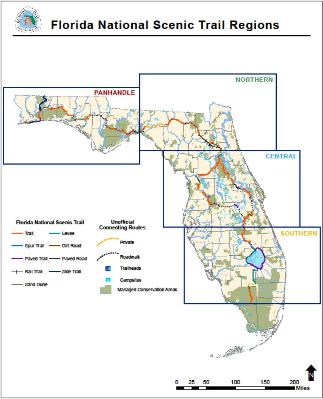
Florida National Scenic Trail: 1 of only 11 NSTs in the country
 FS.USDA.gov
The Florida National Scenic Trail (FNST) is a congressionally-designated, long-distance hiking trail that weaves its way across Florida from Big Cypress National Preserve in the south to Gulf Islands National Seashore in the western end of Florida’s panhandle.
The FNST is a national treasure, being 1 of only 11 National Scenic Trails in the country, and 1 of 3 contained entirely within a single state. The National Scenic Trails System was created to preserve the country’s scenic, historic, cultural, and natural wonders, and the Florida National Scenic Trail provides the opportunity to see unique features in each of these categories.
The Trail is currently about 1,000 miles long, with 1,300 total miles planned. The Forest Service has divided the Trail into four main geographic regions: the Southern region, the Central region, the Northern region, and the Panhandle region.
The USDA Forest Service is the official administrator of the Trail, though the FNST is managed and maintained by 27 different land managers and many dedicated volunteers, including those from the Florida Trail Association.
History
In the 1960s, the Florida National Scenic Trail was just a dream. The Trail’s founder, Jim Kern, saw a need for long-distance hiking opportunities in the state
of Florida, and so he founded the Florida Trail Association to gather like-minded individuals to help him satisfy this need. The first blaze of the Florida National Scenic Trail was marked in the Ocala National Forest in October of 1966, but the Trail was not officially designated as a National Scenic Trail until 1983.
For more information on how to find and use the trail, see:
http://www.fs.usda.gov/main/fnst/about
Tuesday, October 25, 2016
Utah: Comb Ridge parcel privatized: A sign of things to come?
Riveroflostsouls.com - Full Article
Jonathan Thompson
October 24 2016
It was like a sucker punch to the gut last week when the State of Utah sold off 800 acres of land in southern Utah to the highest bidders, the hardest blow being the loss of a 380-acre chunk of Comb Ridge near Bluff. On October 18, and for decades before that, it was public land, a place where locals and visitors could roam freely. Then it wasn't, and likely never will be again.
The Comb Ridge parcel lies just north of Highway 163, and stretches from the crest of what some Navajo call the "backbone of the world" down toward Butler Wash. The Hole-in-the-Rock trail went through here, prompting the Hole-in-the-Rock foundation to nominate it for auction in the first place. The old, abandoned blacktop highway cuts through the parcel, too, both defiling and adding an intriguing feature to the slickrock...
Read more here:
https://riveroflostsouls.com/2016/10/24/comb-ridge-parcel-privatized-a-sign-of-things-to-come/
Monday, October 24, 2016
Texas billionaires will deal on Idaho trail access, Valley County official says
Idahostateman.com - Full Article
October 21 2-16
BY ROCKY BARKER
rbarker@idahostatesman.com
The two Texas billionaire brothers who bought 172,000 acres of forest land in Southern Idaho stopped logging in part because they were worried it was being overlogged, a Valley County official said.
And they were disgusted with the trash they found at the many dispersed campsites spread out across the lands previously owned by Boise Cascade and Potlatch Corp., said Larry Laxson, Valley County Parks and Recreation Director.
Most of all, Laxson said, he is hopeful access for snowmobiles to the county’s extensive trail system can be worked out for this winter. He has been talking to Farris and Dan Wilks and their representatives every week.
“They are very reclusive, they kind of want their privacy,” Laxson said. “They’re good people.”
I first reported in August that the Wilks brothers had purchased the land owned for decades by Boise Cascade in Valley, Adams and Boise counties. The two have been buying up land all over the West, and closing off much of the access to those lands.
The Wilks brothers have closed off the timberlands to hunting and other recreation. They already canceled leases with Valley County to maintain roads that provided access to snowmobile trails on public land...
Read more here: http://www.idahostatesman.com/news/local/news-columns-blogs/letters-from-the-west/article109681742.html#storylink=cpy
Monday, October 3, 2016
A Congressional Update on the Land and Water Conservation Fund
PNTS.org
Land and Water Conservation Fund
Overview:
For 50 years—until Congress let it expire on September 30th, 2015—the Land & Water Conservatiimg-mailon Fund (LWCF) has allowed for the purchase of critical lands for conservation and the development of parks, trails, and other outdoor recreation facilities in all 50 states and nearly every county in America.
Created to invest a portion of the revenue from offshore drilling leases towards protecting parks, forests, wildlife refuges, public lands, and other community spaces— the $900 million LWCF has been a crucial tool for helping to close gaps and preserve critical historic and scenic places within our National Trails System. In 2015 alone, over $25 million LWCF dollars were appropriated by Congress to buy land along 11 of our National Scenic and Historic Trails.
A Congressional Update on the Land and Water Conservation Fund (9/29/2016)
Work continues to convince Congress to permanently re-authorize the Land & Water Conservation Fund via several pieces of legislation under consideration. Two bills in the House of Representatives – HR 1814 sponsored by Representative Raul Grijalva (D-AZ) has 210 sponsors and HR 4151 sponsored by Representative Mike Simpson (R-ID) as an all Republican bill has 13 sponsors – would make the LWCF a permanent program as it now operates. Senate and House members of the conference committee are working to reconcile the energy bills passed by both houses of Congress and are also working to include re-authorization of the LWCF in the final bill. The Senate version of the Energy Bill – S. 2012 – includes the same language that Congressman Simpson used for HR 4151.
There is still hope that one or several of these bills will be adopted by Congress during its post election “Lame Duck” session. Supporters of the Land & Water Conservation Fund should continue to express that support.
Friday, September 30, 2016
Idaho hunters learn Texas billionaires are locking them out at the last minute
Idahostatesman.com - Full Article
September 29 2016
By Rocky Barker
rbarker@idahostatesman.com
Steve Wolfinger was planning to go on what was his first Idaho elk hunt starting Saturday in Adams and Valley counties.
But a week before he was planning to get on a jet to fly from his home in Arkansas, the 70-year-old got a letter from Regan Berkley, an Idaho Department of Fish and Game wildlife manager from McCall. She told him that private land recently owned by Potlatch Corp. that covers much of the unit where he planned to hunt is now closed.
DF Development, the new owners of the 172,000 acres of timberland and a vast road system in Adams, Valley and Boise counties, informed Fish and Game that the land will no longer be open to hunting.
Wolfinger and 304 other hunters had controlled-hunt tags for units where 30 percent of the land is owned by the Cisco, Texas, company. Berkley told those hunters they could trade their controlled-hunt tag for a general elk tag if they wanted.
Hunters go through a lottery to get controlled-hunt tags for units where they have higher odds of bagging an animal. But that won’t work for Wolfinger: He has time to hunt this week, but the general season hasn’t started yet.
“I hope you spread the word,” his son, Bradley Wolfinger, told the Statesman via email. “Outrageous.”
I first reported in August that Farris and Dan Wilks had purchased the land owned for decades by Boise Cascade. The two Texas billionaires have been buying up land all over the West, and closing off much of the access to those lands.
Read more here: http://www.idahostatesman.com/news/local/news-columns-blogs/letters-from-the-west/article104921951.html#storylink=cpy
Thursday, September 29, 2016
National Forest Trail Maintenance Legislation Passes House
September 28, 2016 - The American Endurance Ride Conference’s Trails and Land Management Committee is pleased to announce that the House of Representatives approved H.R. 845 this week the National Forest System Trails Stewardship Act.
Representatives Cynthia Lummis (R-WY) and Tim Walz (D-MN) introduced the legislation, which would keep more trails across the nation open and accessible by expanding the use of volunteer and partner organizations and providing increased focus on a handful of priority areas around the country.
AERC has been a proponent of the bill, working alongside The Wilderness Society, the American Horse Council and Back Country Horsemen of America and more than 100 other equestrian, sportsmen, conservation, motorized recreation, outfitters and guides, trails, and governmental organizations.
The bipartisan bill is co-sponsored by 87 members of the House of Representatives, and the Senate version, S.1110, is set for “fast-tracking” with hopes that it will be signed into legislation before the end of 2016.“
We have been working toward this for almost two years,” said AERC Trails and Land Management Committee Chair Monica Chapman of Kansas. “AERC signed on early as one of the sponsors. This advocacy is part of what our members are getting as part of their dues—this is what the Trails Committee is doing to help secure the future of trails for all endurance riders.”
Chapman has visited Washington, D.C. multiple times, and has spent time visiting Senate and Representative offices as a proponent of H.R. 845 and other measures that will benefit all riders who use trails, both for casual riding and in endurance competitions.
“National forest and trails are important to thousands of recreational riders and are a vital component of the $32 billion recreational riding industry,” said Ben Pendergrass, senior vice-president of policy and legislative affairs at the American Horse Council. “This bill will help make certain that equestrians and all trail users are able to have access to and enjoy our national forests. The AHC hopes the Senate will move quickly to also approve this bill.”
“We are overjoyed that Congress recognized the need to improve the condition of trails on our national forests,” affirmed Back Country Horsemen of American Chairman Donald Saner. “We applaud Representatives Lummis and Walz and urge swift action in the Senate.
”Trails advocacy has been a vital component of AERC. Since its inception in 1972, AERC has been a leader in encouraging the use, protection and development of equestrian trails, especially those with historical significance. AERC, through its active Trails and Land Management Committee, seeks to promote awareness of the importance of trail preservation for future generations, and foster an appreciation of our American heritage.
Tuesday, September 27, 2016
House of Representatives Passes National Forest Service Trail Stewardship Act
September 26 2016
Today, the House of Representatives passed the National Forest Service Trail Stewardship Act of 2015 (H.R.845). The bill, introduced by Representatives Cynthia Lummis (R-WY) and Tim Walz (D-MN), would direct the Forest Service to take several actions to help address the current trail maintenance backlog that is adversely impacting all trail users on many national forests, including equestrians. The American Horse Council, Backcountry Horsemen of America, and the Wilderness Society were significantly involved in the creation of this bill.
The AHC strongly supports the National Forest Service Trail Stewardship Act of 2015 and is pleased the House has approved this important legislation.
A June 2013, study by the Government Accountability Office (GAO) found that the Forest Service has deferred trail maintenance needs that exceed half-billion dollars, and only one-quarter of the agency’s 158,000 miles of trails meets agency standards for maintenance. This maintenance backlog is causing access and safety issues for equestrians and all trail users on national forests.
The National Forest Service Trail Stewardship Act would direct the Forest Service to develop a strategy to more effectively utilize volunteers and partners to assist in maintaining national forest trails. It will also provide outfitters and guides the ability to perform trail maintenance activities in lieu of permit fees. Additionally, the bill would address a liability issue that has discouraged some national forests from utilizing volunteers and partner organizations to help perform trail maintenance and would direct the Forest Service to identify and prioritize specific areas with the greatest need for trail maintenance in the national forest system.
In the current fiscal environment it is unlikely Congress will appropriate additional funds to directly address the trail maintenance backlog. This bill will help improve trail maintenance without the need for additional funding.
The bill must now be considered by the Senate.
Friday, September 23, 2016
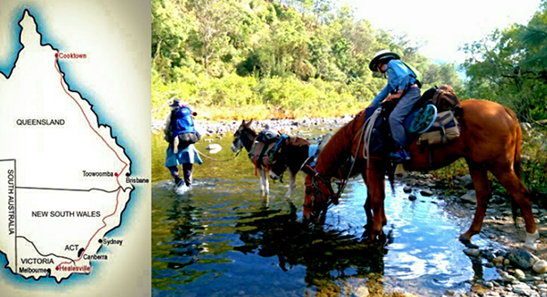
Riding Australia’s Challenging Bicentennial National Trail
 Equitrekking.com - full article
August 19, 2016
Read about a mother and daugther team, who with two little pack donkeys and a trusty Thoroughbred are traveling over 3000 miles across Australia on the Bicentennial National Trail.
by Eliza Allan
It had been my dream for quite some time to save up and take a year off work to travel with my young daughter. But where? And how? Backpacking through Europe? Volunteering in orphanages in South East Asia? We live in a world full of opportunities and choices, and at times it can be hard to finally bite the bullet and make a decision. I knew that I wanted this year to be big- something neither of us would ever forget. I also wanted a challenge; something that would push the both of us out of our comfort zones and force us to learn to draw on our inner strength.
So when I heard about Australia's Bicentennial National Trail, I was enthralled. Previously known as the National Horse Trail, the BNT stretches an incredible 3311 miles (5330km) between Healesville in the south and Cooktown in far north Queensland. It follows the foothills of the Great Dividing Range and the Eastern Escarpment, revealing some of the most spectacular scenery in the country. The trail provides access through some of Australia’s wildest, most inaccessible country, and is thought to be the longest trail of its type in the world.
After further research, I found that previous trekkers had tackled the trail by donkey, horseback, on foot, by bicycle, and even with camels. However, not many had made it through the whole 3000 some miles. Being a horse-mad woman from way back, I was sold. I had found our big year, our dream trip, our challenge! I decided that over the course of the next 18 months, I would acquire suitable horses and prepare them for the challenges of the trail...
Read more here:
http://www.equitrekking.com/articles/entry/riding-australias-challenging-bicentennial-national-trail/?mc_cid=10736cb351&mc_eid=290b655fe3
Wednesday, September 21, 2016
Dawn Davis Joins ELCR Board of Directors
Lexington, Ky. – (9/12/16) – Equine Land Conservation Resource (ELCR) is proud to announce the appointment of Dawn Davis to the Board of Directors. ELCR’s Board of Directors brings together a team of equine industry experts with a wealth of talent and experience to direct the country’s only national organization dedicated to saving land for all equine related activity.
Ms. Davis currently resides in the prominent equestrian community of Barrington Hills, Ill., where she and her husband, J.R., preside over Barrington Hills Farm. They are both avidly devoted to preserving land for horses in the village of Barrington Hills. Dawn and J.R. are actively involved in equine rescue efforts in the Chicago area through their alliance with HARPS (Hooved Animal Rescue & Protection Society). Ms. Davis is Vice Chairman of Davis Bancorp and also contributes time to many other civic duties, including serving as director of the Chicago Zoological Society (Brookfield Zoo), Chicago Crime Commission, Chicago Cultural Mile, and the Smith Museum of Stained Glass and American Art.
“We are delighted with the addition of Dawn Davis to the board of directors,” says ELCR President Ken Haddad. “She’s bringing expert representation and commitment from an important region of our country and for that we are grateful.”
About the Equine Land Conservation Resource (ELCR): ELCR builds awareness of the loss of lands available for horse-related activities and facilitates the protection and preservation of those lands. We work to ensure America’s equine heritage lives on and the emotional, physical and economic benefits of the horse-human relationship remains accessible. ELCR serves as an information resource and clearinghouse on conserving horse properties, land use planning, land stewardship/best management practices, trails, liability and equine economic development. For more information about the ELCR visit www.elcr.org or call (859) 455-8383
For additional information, contact:
Holley Groshek, Executive Director
Equine Land Conservation Resource
Phone: 859-455-8383/Email: hgroshek@elcr.org
www.ELCR.org
Tuesday, September 20, 2016
New plan to give US horse riders better off-road equestrian access
Horsetalk.co.nz - Full Article
September 20, 2016
Horsetalk.co.nz
The United States’ forest trails for equestrian and recreational access have received a boost with the country’s House Agriculture Committee approving a Trail Bill.
The National Forest Service Trail Stewardship Act of 2015 (H.R.845) has been unanimously approved by the House Committee on Agriculture. The bill, introduced by Congresswomen Cynthia Lummis (R-WY) and Tim Walz (D-MN), would direct the Forest Service to take several actions to help address the current trail maintenance backlog that is adversely impacting all trail users in many National Forests, including equestrians.
“The recreational horse industry contributes $US32 billion a year to the economy and supports nearly 435,000 jobs nationwide,” said American Horse Council president Julie Broadway...
Read more: http://www.horsetalk.co.nz/2016/09/20/new-plan-horse-riders-off-road-equestrian-access/#ixzz4KprubG7C
Be Part Of Public Lands Day On September 24
Nationalparkstraveler.com
By NPT Staff on September 19th, 2016
ou can be a part of the nation's largest, single-day volunteer effort for public lands this coming Saturday. Throughout the country, about 200,000 people will participate in 2,500 National Public Lands Day events. As part of the celebration, national parks will waive entrance fees and host projects and programs that promote environmental stewardship.
"Whether a neighborhood park or a national park, public lands belong to all of us," said National Park Service Director Jonathan B. Jarvis. "They might vary in shape and size but they all exist for all of us. Join us on National Public Lands Day and help ensure that these special places can continue to be used for recreation and inspiration."
All 413 National Park Service sites will have free entrance on National Public Lands Day. Those who volunteer for a service project will receive a voucher that permits them into a national park for free on a different day.
Dozens of National Park Service sites will host events. Take part in spring cleaning in Yosemite National Park, repair a horse trail in Catoctin Mountain Park, preserve earthworks at Richmond National Battlefield Park, or restore the tall grass prairie at Pipestone National Monument...
See more here:
http://www.nationalparkstraveler.com/2016/09/be-part-public-lands-day-september-24
Friday, September 16, 2016
National Forest Trail Bill Approved by House Agriculture Committee
September 15 2016
Today, the House Committee on Agriculture unanimously approved the National Forest Service Trail Stewardship Act of 2015 (H.R.845). The bill, introduced by Congresswomen Cynthia Lummis (R-WY) and Tim Walz (D-MN), would direct the Forest Service to take several actions to help address the current trail maintenance backlog that is adversely impacting all trail users on many national forests, including equestrians. The American Horse Council, Backcountry Horsemen of America, and the Wilderness Society were significantly involved in the creation of this bill.
A June 2013, study by the Government Accountability Office (GAO) found that the Forest Service has deferred trail maintenance needs that exceed half-billion dollars, and only one-quarter of the agency’s 158,000 miles of trails meets agency standards for maintenance. This maintenance backlog is causing access and safety issues for equestrians and all trail users on national forests.
The National Forest Service Trail Stewardship Act would direct the Forest Service to develop a strategy to more effectively utilize volunteers and partners to assist in maintaining national forest trails. It will also provide outfitters and guides the ability to perform trail maintenance activities in lieu of permit fees. Additionally, the bill would address a liability issue that has discouraged some national forests from utilizing volunteers and partner organizations to help perform trail maintenance and would direct the Forest Service to identify and prioritize specific areas with the greatest need for trail maintenance in the national forest system.
In the current fiscal environment it is unlikely Congress will appropriate additional funds to directly address the trail maintenance backlog. This bill will help improve trail maintenance without the need for additional funding.
The AHC is pleased the House Committee on Agriculture has approved this important legislation.
The bill must now be considered by the full House.
Tuesday, September 6, 2016
Lewis and Clark National Historic Trail Extension Study
Dear Friends of the National Park Service and the Lewis and Clark National Historic Trail,
I am writing to update you on the status of the Lewis and Clark National Historic Trail Extension Study, also known as the Eastern Legacy study. The draft study will be available for review and comment for 45 days, August 15 until September 30.
As directed by Congress, the purpose of the study is to evaluate eastern sites and segments associated with the Lewis and Clark expedition to determine whether those sites and segments should be added to the existing trail. The National Park Service researched, mapped, and evaluated 25 trail segments and additional sites using the criteria outlined in the National Trails System Act. While preparing the draft study, the National Park Service planning team considered public comment and consulted experts on the Lewis and Clark expedition.
Contact Information
Tokey Boswell, Chief, Planning Program, Midwest Regional Office, National Park Service, 601 Riverfront Drive, Omaha, Nebraska 68102, 402-661-1534, Email: tokey_boswell@nps.gov
For more information, see
https://parkplanning.nps.gov/projectHome.cfm?projectID=32773
American Trails Webinar: "Understanding the National Recreation Trails Program and National Water Trails System"
 Americantrails.org
American Trails hosts this Webinar on September 8, 2016. Join us to find out how your local trail efforts can shine in the national spotlight! This webinar will introduce you to the National Recreation Trails Program and the National Water Trails System. This webinar is presented by Rory Robinson and Helen Scully with the National Park Service, Jarrett Caston with the U.S. Forest Service, and Liz Sparks with Florida Office of Greenways & Trails.
Date: September 8, 2016
Time: 10:00 a.m. – 11:30 a.m. Pacific (1:00 p.m. - 2:30 p.m. Eastern)
Cost: FREE
CEUs: Continuing Education Unit credit of 0.10 for attending this webinar is available for an additional charge of $20
WEBINAR OUTLINE
Presenters will highlight the benefits and the value of National Recreation Trails Program and National Water Trails System designation, point out the criteria and requirements for designation, show you how to apply, and relate the experiences of a newly designated trail.
Applications for the next round of designations are being accepted until November 1, 2016.
Rory Robinson will give a brief overview of the National Recreation Trails and National Water Trails programs focusing on the benefits and the value to those who choose to participate in these opportunities.
Helen Scully will introduce the enabling legislation, the criteria and requirements for designation, the information needed for an application, and how to apply. She will walk through the National Recreation Trails website, the NRT online application, the National Water Trails System website, as well as the NWT online application.
Jarrett Caston will discuss the application process for trails administered by the U.S. Department of Agriculture that include National Forests, National Grasslands, and National Recreation Areas, and associated lands.
Liz Sparks will discuss strategies for achieving success in the designation process, as well as ways to gain support from private and public partners.
for more information, see:
http://americantrails.org/resources/feds/Webinar-Caston-NRTProgram.html
Monday, August 29, 2016
The Great Trail Debate: Stop Making Trails
Outsideonline.com - Full Article
Should we continue blazing trails into wild places? Kenneth Brower doesn't think so.
By: Kenneth Brower
Aug 12, 2016
ne months before the discovery of the largest oil field in North America at Prudhoe Bay in Alaska, the executive director of the Sierra Club sent a team of three of us north to Alaska, on a premonition. It was clear by then, summer of 1967, that a big strike on the North Slope was likely. Our assignment was to gather materials for a large-format photographic book defending the nation’s last great wilderness against Big Oil.
I was 22, the writer. My two photographer companions and I flew in by bush plane to Last Lake on the Sheenjek River, then walked for five weeks across the Brooks Range and out to the Arctic Ocean.
Near the shore of Last Lake, before we departed, I found the cache of a native Alaskan Gwich’in hunter, a tiny shake cabin elevated atop peeled spruce poles. No wolverine or grizzly had figured how to climb the poles. The door remained intact. Inside I found the hunter's draft card; his name was Ambrose William. We left William's cache behind us and walked north in perpetual daylight for more than a month without seeing another sign of human being—not a blaze on a tree, not a corroded tin can, not a dropped penny, nothing. We had entered a perfect traillessness.
In our photo book on the Brooks Range, and in a follow-up book I co-authored on the Trans Alaska Pipeline southward from Prudhoe Bay, we laid out all the threats: disruption of caribou migration by the pipe; the thawing of permafrost underneath it; the slow biodegradation of any leaks, marine or terrestrial; the seismic terrain traversed; the narrow waterways that supertankers would have to negotiate with Prudhoe oil. (We predicted the wreck of the Exxon Valdez 15 years before that ship was built.) But nothing about the pipeline itself worried us, and other environmentalists, more than did the service roads for pipeline maintenance. There is nothing more fatal to wilderness than a road. Roads open up the country to vehicles, prospectors, recreational hunters, the occasional arsonist. Roads have “edge effects” from which wilderness unravels to either side. The trail is a primitive road on a much smaller scale, but with similar dynamics...
Read more here:
http://www.outsideonline.com/2105181/great-trail-debate-we-dont-need-any-more-trails?utm_source=dispatch&utm_medium=newsletter&utm_campaign=08232016&spMailingID=26315294&spUserID=MjY1ODQxODc4MTkzS0&spJobID=864088160&spReportId=ODY0MDg4MTYwS0
The Great Trail Debate: Why Wilderness Needs More Trails
Outsideonline.com - Full Article
Should we ban the construction of any more trails into the wilderness? Robert Moor, author of the new book, 'On Trails,' says we should build more.
By: Robert Moor
Aug 13, 2016
Back in 1930, Bob Marshall—legendary outdoorsman, bestselling author, and grandpappy of the environmental movement—set out to define what the wilderness is. He settled on two basic preconditions: “first, that it requires anyone who exists in it to depend exclusively on his own effort for survival; and second, that it preserves as nearly as possible the primitive environment.” This means that all roads, mechanical transportation, and human habitation would be forbidden. But according to Marshall, trails—the most ‘primitive’ of all our myriad inventions—would be “entirely permissible.”
This belief was later reflected in the first version of the National Wilderness Preservation Act, introduced to the Senate in 1957, which defines wilderness as a place where “man” is “a wanderer who visits but does not remain and whose travels leave only trails.” That’s the thing about trails: if enough people visit a piece of land, they are going to make them. It’s what we as a species—we as animals—instinctively do. The act of creating and following trails is one of the oldest and most profound ways that we make sense of this chaotic planet we all live on.
The question, then, is not whether we want to make trails, but how—with our feet, or with our hands? In other words, do we want to create them unconsciously and with little foresight? Or do we want to build them deliberately, with the aim of making them as sustainable as possible?...
Read more here:
http://www.outsideonline.com/2105176/great-trail-debate-why-wilderness-needs-more-trails?utm_source=dispatch&utm_medium=newsletter&utm_campaign=08232016&spMailingID=26315294&spUserID=MjY1ODQxODc4MTkzS0&spJobID=864088160&spReportId=ODY0MDg4MTYwS0
Wednesday, August 24, 2016
California: EBMUD Opening up Watershed Trails
Lamorindaweekly.com - Full Article
Published August 24th, 2016
By Nick Marnell
Mountain bikers will soon be able to share popular East Bay Municipal Utility District trails with hikers and equestrians if a proposed two-year pilot program for equal access is approved as part of the EBMUD Watershed Master Plan. The trial period would begin next summer and will feature four sections of district trails that connect to regional trail systems, including the Bay Area Ridge Trail.
The watershed comprises 28,000 acres of East Bay property that the district manages in order to protect the quality of drinking water for its 1.3 million customers and to promote biological diversity. Sections of the watershed familiar to Lamorindans include the Upper San Leandro Reservoir south of Moraga, the Briones Reservoir and the San Pablo Reservoir Recreation Area near Orinda and the Lafayette Reservoir.
"This issue has received the most attention, more than our historic drought," said EBMUD director Marguerite Young, who told a standing room crowd at district headquarters Aug. 15 that she favored equal trail access. Moraga and Orinda reside in Young's Ward 3.
Concerns for safety and the destruction of the natural environment highlighted the presentations of nearly 60 speakers, whose comments appeared to be fairly balanced between the pro and anti-bicyclists...
Read more at:
http://www.lamorindaweekly.com/archive/issue1013/EBMUD-Opening-up-Watershed-Trails.html
Tuesday, August 23, 2016
Free Webinar: "Understanding the National Recreation Trails Program and National Water Trails System"
Americantrails.orgThursday, September 8, 2016
10:00 a.m. - 11:30 a.m. PACIFIC
(1:00 p.m. - 2:30 p.m. EASTERN)
COST: FREE FOR ALL!
(CEUs are available for $20)
Description:
Join us to find out how your local trail efforts can shine in the national spotlight! This webinar will introduce you to the National Recreation Trails Program and the National Water Trails System. Thanks to a partnership with the National Park Service, this webinar is free to the public!
Presenters:
• Rory Robinson, National Park Service
• Helen Scully, National Park Service
• Jarrett Caston, U.S. Forest Service
• Liz Sparks, Florida Office of Greenways & Trails
Learn more about this webinar and the presenters, as well as how to register HERE.
CEUS: If you are interested in receiving CEUs for this webinar ($20 fee), please be sure and select YES to that question when registering and purchase the CEUs through our online store.
Questions for the Presenters:
Feel free to send in your questions prior to the webinar as we saved time for questions and answers (Q&A) at the end.
For more information, see:
http://americantrails.org/resources/feds/Webinar-Caston-NRTProgram.html
Sunday, August 21, 2016
Biking bill is a smokescreen for opening up wilderness
HCN.org - Full Article
John Kelley
OPINION
Aug. 17, 2016
Are you ready for mechanized vehicles on every wilderness trail in the United States? That's what you'll get if a deceptive piece of federal legislation becomes law. Portrayed as a “modest” proposal for mountain bike access, the legislation is a Trojan horse that would throw open all designated wilderness areas to bikes and prevent federal land managers from later excluding them.
The "Human-Powered Travel in Wilderness Areas Act" was introduced into Congress by Utah Republican Sens. Orrin Hatch and Mike Lee, both known for their efforts to roll back environmental protection. You can read it online.
Hatch calls the legislation "a reasonable approach to allowing the use of mountain bikes on trails." Lee says it would allow local land managers to decide whether to allow mountain biking in wilderness areas. Both statements are smokescreens designed to hide what’s really going on...
Read more here:
http://www.hcn.org/articles/biking-bill-is-a-smokescreen-for-opening-up-wilderness?utm_source=wcn1&utm_medium=email
Friday, August 19, 2016
Nevada Equestrians: Give your trail opinions!
 Surveymonkey
Nevada State Parks - in cooperation with both the National Park Service and Federal Highway Administration - distributes millions of dollars in grants each year, to awardees around the state.
These grants go to projects both large and small: from new signs on a local bike path, to the installation of entire playgrounds and major new trail systems.
To make the most of these funds, State Parks must understand the needs and goals of Nevada residents - thank you for providing your thoughts and ideas.
Take the survey here:
https://www.surveymonkey.com/r/OutdoorRecNV
Thursday, August 18, 2016
NPS Paramount Ranch Proposed as 2024 Olympic Mountain Bike Training Ground
by Stephanie Abronson
A HEADS-UP CALL:
Save this date and please show up to express your concern -- August 23, 2016, Tuesday, NPS Diamond X Ranch, 26412 Mulholland Hwy., Calabasas, CA 91302 at7:00 PM
Mountain Biking is a future Olympic Sport in 2024. This may be the worst and most ecologically abusive event to be added to the Olympic roster for the damage it will cause to our environment. Mountain Bikers will need a training area specifically for them to race and crash without endangering all other trail users. Los Angeles Mayor Eric Garcetti proposes that NPS Paramount Ranch be used as an Olympic Mountain Bike Training ground in 2024. This proposal is inappropriate!
A copy of my letter to David Szymanski, Superintendent, National Park Service, Santa Monica Mountains National Recreation Area, may be used to help other folks to chime in against the Garcetti proposal to use NPS’s Paramount Ranch -- nor any other area in the Santa Monica Mountains National Recreation Area for future Olympic Mountain Bike training. Remember the SMMNRA is located in the California Coastal Commission zone. Wouldn’t a Coastal Permit be required to improve any training area in the SMMNRA?
Think of the Mountain Biker’s hope of gaining a spot on the United States Team, the amount of training – months and years - that goes into any Olympic sport, and what it will mean to the ecological systems in all the countries that support a Mountain Bike team!!
Mountain Biking takes place in mountainous terrain, most often in our state, national, and historic parklands. Training for this event will cause irreparable damage to all natural habitats the bikers come in contact with. Think what will this mean to those of us who must use the same trails for hiking and horseback riding? We will end up giving up our use of our trails for fear that our safety cannot be secured.
Think also of the local traffic congestion should Paramount Ranch be designated an Olympic training area. It is promised that “restoration” will occur after the Games. But that is only for Paramount Ranch. Fat chance! All the local California parklands will be overrun and damaged, not just Paramount Ranch. We are now in a 5-year drought! Think what will happen during our expanding spring, summer to fall Fire season!
Encourage the members of the Sierra Club, Audubon Clubs, and others to join in this effort to protect the Santa Monica Mountains NATIONAL Recreation Area.
Send your letters to:
David Szymanski, Superintendent, Email:david_szymanski@nps.gov
Santa Monica Mountains National Recreation Area
United States Department of the Interior,
National Park Service,
401 West Hillcrest Drive,
Thousand Oaks, California 91360-4207
Sally Jewell, Secretary
Department of the Interior
1849 C Street, N.W.
Washington DC 20240
U.S. Fish & Wildlife Service, Pacific Southwest Region
Jody Holzworth, Assistant Regional Director, External Affairs
2800 Cottage Way W-2606,
Sacramento, CA 95825
Joe Edmiston, Executive Director Email:info@smmc.ca.gov
Santa Monica Mountains Conservancy
57S0 W Ave 26 #100,
Los Angeles, CA 90065
Craig Sap Email: craig.sap@parks.ca.gov
Angeles District Superintendent,
California State Parks
1925 Las Virgenes Rd.
Calabasas, CA. 91302
Santa Monica Mountains Trails Council
P.O. Box 345
Agoura Hills, Ca 91301
Howard Cohen howard@gravityh.com
Appaloosa Horse Club Celebrates History at the 52nd Annual Chief Joseph Trail Ride
August 17 2016
MOSCOW, IDAHO — Over 250 riders, drivers and spectators from across the nation and around the world gathered together to experience in the 52nd Annual Chief Joseph Trail Ride organized by the Appaloosa Horse Club (ApHC), July 18-22, 2016. The Chief Joseph Trail Ride is a progressive trail ride tracing, as closely as possible, the route Chief Joseph and the Nez Perce took while attempting to escape the US Cavalry in 1877. A different segment of this monumental journey is covered each year.
This year’s ride marked the fourth time the ride reached the final leg at Bear Paw Battlefield near Chinook, Montana where the historic Battle of the Bears Paw took Place. The first sequence was completed in 1977. The Appaloosa Horse Club worked closely with the Nez Perce Tribe to coordinate a variety of special presentations and ceremonies in respect of this significant event where after five days of battle with the US Calvary, Chief Joseph spoke the everlasting words, “From where the sun now stands, I will fight no more forever.”
Riders from twenty U.S. states as well as Germany, the United Kingdom and Norway attended this year’s event. Some participants such as Anne Mischel have attended all 52 years of the ride. Participating in this ride is a remarkable experience that has been described as moving and unforgettable.
Be sure to watch for the November 2016 issue of Appaloosa Journal for additional coverage of the 52nd Annual Chief Joseph Trail Ride. For information on the ApHC Trail & Distance Program and ApHC- sponsored trail rides contact (208) 882-5578 ext. 264.
The Appaloosa Horse Club (ApHC) was established in 1938 with a mission of honoring the heritage and promoting the future of the Appaloosa horse. The ApHC has since registered more than 700,000 Appaloosas, which are known for their distinctive color, intelligence and even temperament. True to their reputation as an extremely versatile breed, Appaloosas can be found in nearly every discipline including racing, endurance riding and serving as reliable family horses. The international breed registry is headquartered in Moscow, Idaho, the heart of the Palouse region—the Appaloosa breed’s namesake and point of origin.
Wednesday, August 10, 2016
Montana: Landowner contests Forest Service trail in Crazy Mountains
Billingsgazette.com - Full Article
By BRETT FRENCH french@billingsgazette.com
Jul 17, 2016
A Big Timber-area landowner and the Forest Service have locked horns over an old trail that crosses private land on the eastern face of the Crazy Mountains to access hard-to-reach federal lands.
Hailstone Ranch owners Lee and Barbara Langhus have hired Livingston attorney Joseph Swindlehurst to counter the Forest Service’s contention that Trail 115, also shown as Trail 136 on some maps, is a public prescriptive easement across their property.
“My clients are not aware of any easement that the public or the Forest Service has to cross their property,” Swindlehurst wrote in a March 25 letter to Alex Sienkiewicz, the Yellowstone District ranger based in Livingston.
Old trail
The Forest Service sees things differently...
Read more here:
http://billingsgazette.com/lifestyles/recreation/landowner-contests-forest-service-trail-in-crazy-mountains/article_e68a8df7-59e4-5166-b740-b4efa00dab1e.html
Sunday, August 7, 2016
Utah Lawmakers Introduce Bill That Could Allow Bikes in Wilderness
Flatheadbeacon.com - Full Article
Tester opposes proposal; Daines still reviewing legislation as debate resurfaces
By Dillon Tabish // Jul 25, 2016
Two Utah senators have introduced legislation that would allow federal officials, such as U.S. Forest Service supervisors, to decide whether mountain bikes could be used on sections of trail in designated wilderness areas.
U.S. Sens. Mike Lee, R-UT, and Orrin Hatch, R-UT, are proposing the Human-Powered Travel in Wilderness Act, a bill that would change the rule banning bikes in protected wilderness, such as the Bob Marshall Wilderness Complex.
The bill would allow local land managers to decide whether to permit mountain bikes in wilderness areas, for both recreational and management purposes, as well as allow federal employees or designees to use non-invasive, minimal technology to maintain wilderness trails.
“Our National Wilderness Preservation System was created so that the American people could enjoy the solitude and recreational opportunities of this continent’s priceless natural areas,” Lee stated after introducing the bill on July 13. “This bill would enrich Americans’ enjoyment of the outdoors by making it easier for them to mountain bike in wilderness areas.”
The debate over bikes in protected wilderness has intensified in the decades since 1984, when the Forest Service explicitly outlawed “mechanized transport” in those areas...
Read more here:
http://flatheadbeacon.com/2016/07/25/utah-lawmakers-introduce-bill-allow-bikes-wilderness/
Friday, August 5, 2016
Why does the outdoor recreation community ignore horseback riders?
HCN.org - Full Article
We love and make use of our public lands, but we get no respect.
Maddy Butcher
OPINION
Aug. 2, 2016 Web Exclusive
The cover of a recent outdoor-gear catalog featured two men on horseback looking cool and competent. Marvelous, I said to myself: An outdoor recreation company is acknowledging that horse riders also love the outdoors.
Alas, the photo caption made no mention of horses, their utility or their traditional use in that country. For me, it was just another example of how the outdoor recreation community ignores people who prefer to get outdoors on horseback. We love and make use of our public lands, but we get no respect, either on the trail or in the trade.
Consider outdoor recreational marketing. Along with about 27,000 annual people, I’ve been attending the Outdoor Retailer trade show in Salt Lake City for years. It’s the major buying event for retailers and a major networking event for everyone else.
When I go, I make a point of wearing cowboy boots and jeans, and I like to explain to people selling outdoor gear exactly why I’m there. I talk about how we horse folks explore the wilds as much as bikers, hikers, runners and boaters...
Read more here:
http://www.hcn.org/articles/why-does-the-outdoor-recreation-community-ignore-horseback-riders?utm_source=wcn1&utm_medium=email
Yosemite Wilderness Stewardship Plan
Yosemite National Park resides in central California on the western flank of the Sierra Nevada Mountain Range. Known for its breath taking valleys, sheer granite walls and domes, abundant vegetation and wildlife, and pristine rivers and streams, Yosemite has long been a place for inspiration, wonder, and discovery.
Officially designated by the California Wilderness Act in 1984, the Yosemite Wilderness area comprises over 94%, or about 704,000 acres, of the total area of Yosemite. Many of the destinations and vistas that draw people to the park reside within the designated wilderness boundary.
The Yosemite Wilderness Area is currently managed under the 1989 Wilderness Management Plan. Although effective, changing use patterns, increased visitation numbers, and emerging threats to resources have prompted the park to develop an update to the Plan. The purpose of the Yosemite Wilderness Stewardship Plan and Environmental Impact Statement (WSP/EIS) is to review the management direction established by the 1989 Plan and update it as necessary to better align with contemporary use patterns and NPS policy.
In particular, there is a need to examine and refine the existing plan to incorporate new information and understanding about changes in visitor use patterns, methods of managing visitor use, techniques for trail design and construction, and concepts for managing stock in wilderness settings. There is also a need to incorporate new policy direction and definitions for wilderness character into the park's wilderness management framework. Finally, there is a need to determine the extent to which commercial services are necessary in the Yosemite Wilderness.
The Wilderness Stewardship Plan will apply to both visitor and administrative use (National Park Service and concessioner) in wilderness. While some site-specific actions may be necessary, the primary focus of the plan will be to provide a framework for measuring and monitoring wilderness character to ensure that future management actions will be taken as needed to adapt to changing conditions.
The Park initiated the WSP/EIS in November 2015 and conducted a public scoping comment period from November 10th, 2015 to January 29th, 2016. The Park hosted two meetings and three webinars, in an effort to engage the public and other stakeholders in the planning process. The Park will continue to seek public opinion throughout the planning process, including the current release of our preliminary concepts and ideas. This period for public feedback will be open through September 30th, 2016 and will include workshops and webinars open to the public. For more information, please see the "meeting notices" tab on the left hand side of this page.
We look forward to hearing from you!
Contact Information
Yosemite National Park, Strategic Planning Division
(209) 379-1218
Horse and Camp at Mueller State Park, Colorado

Mueller State Park has a brand new adventure awaiting horse-back riders! Equestrians can now camp at the park with their horses and get up bright and early to ride the trails. With expanded trails this year, Mueller offers over 30 miles of trails through rolling meadows, forested canyons and the mountain beauty that is Mueller State Park!
Whether you plan to come for the day, or spend the night, your journey begins at the Livery where there's room for numerous trucks and trailers to park and unload. Water is available and the horse trails begin from there. Adjacent to the Livery are the equestrian campsites. These two campsites offer electricity, a tent pad and RV space, a 12 x 24 corral for each site and round pen use. You can enjoy the peace, quiet and beautiful view of Pike's Peak, tucked in and away from the main campground.
Equestrian campsites can be reserved by calling 1-800-678-2267. You can see the availability online, but they must be reserved by phone. Please bring your own weed-free feed, water buckets (hydrant available) and tools for clean up. Please call the park for more information 719-687-2366.
The campsite cost $26 per night, plus $10 per horse per night. In addition, each vehicle needs a park pass, $7 per day or $70 annual.
Make some new memories! You, your friends, and your horse - it doesn't get much better than that!
Mueller State Park is located just 45 minutes from Colorado Springs on the west side of Pike's Peak.
Colorado Parks and Wildlife manages 42 state parks, more than 300 state wildlife areas, all of Colorado's wildlife, and a variety of outdoor recreation. For more information go to cpw.state.co.us.
Tuesday, August 2, 2016
National Public Lands Day to be Held September 24th
August 1 2016
This year's National Public Lands Day is just around the corner. This is a great opportunity to garner volunteer support and promote the National Trails System. Is your trail organization hosting an event? We want to hear about it! Send us your stories and photos to be featured in the upcoming issue of Pathways Across America.
Need help planning? The National Environmental Education Foundation has created a promotional kit that provides tips on planning activities, creating communications plans, utilizing online media, recruiting volunteers, and more.
Thursday, July 28, 2016
Access To Western States Trail Closed?
July 22 2016
Road closure will impact your access to Western States Trail and White Oak Flat. You can make a difference if attend the public meeting and write/email these government officials.
-Regarding the proposed closure of McKeon Ponderosa Rd. which would limit public access to White Oak Flat and the Western States Pioneer Express National Recreation Trail (WST): The Foresthill Forum will be hearing this issue August 1, 2016, 7PM at 24601 Harrison St. Foresthill. It is imperative that interested parties show up, write letters and voice their concerns re the loss of the public access to this trail. For the agenda of the Forum and additional information go to Placer County website: http://www.placer.ca.gov/ForesthillForumMAC
From one of the Loomis Basin Horsemen's Association members:
"Access to White Oak Flat (BLM/BOR land) and ASRA Gate 102 to Francisco's and beyond has become a complex issue. There are a few homeowners towards the end of McKeon Ponderosa Way who have wanted for years to have a gated community, for various reasons.
In 2002, when this issue came up, County Public Works clearly informed everyone that public use of their end of the road could not be denied. However, one of those homeowners recently discovered an old document from the County apparently abandoning that portion of the road in the late 1980's. He has put up private road signs and wants to put in a gate. Now the County appears to be looking for BLM/ASRA to step up and state it is against their wishes for the public to be denied access to these long-used public lands.
Thus everyone needs to contact these public agencies if historic White Oak Flat and the trails leading out from McKeon Ponderosa Way are to be protected for all to use! We need a dedicated public easement to the White Oak Flat staging area! Let us see all of our public agencies work together to protect the public's interest in one of Foresthill's best assets, its recreational trails! Please contact these people listed below and help protect this historic area.
Supervisor Montgomery: JMontgomery@placer.ca.gov
Michael Schneider, ASRA Superintendent: michael.schneider@parks.ca.gov
Jeff Horn, Regional Manager of BLM: jhorn@blm.gov
Florida: Officials Agree to Conduct Horse Trail Study in Oldsmar
Oldsmarconnect.com - Full Article
After months of refusing to reopen the public horse trails in Mobbly Bayou Preserve, Oldsmar officials agreed on Tuesday to conduct a study to determine the feasibility of having trails in the city.
After months of refusing to reopen the horse trails in Mobbly Bayou Preserve despite repeated pleas by advocates of the cause, Oldsmar officials finally relented and agreed to conduct a study regarding the feasibility of having trails in the city.
The decision came after another round of debating the oft-contentious topic during Tuesday night’s City Council meeting, as the issue was addressed for the first time as an official agenda item.
And while officials cautioned the ruling doesn’t guarantee there will ever be public trails in the preserve, advocates consider the fact that the city was willing to look into the issue as a win.
“I’m so excited, I’m beyond words,” Estela Orosz, a longtime supporter of the trails and the sister of Horsepower For Kids owner Armando Gort, told Oldsmar Connect after the meeting.
“I feel that we’re being heard, and I feel that they’re being respectful of us. So I’m hopeful...”
Read more here:
http://oldsmarconnect.com/officials-agree-to-conduct-horse-trail-study-in-oldsmar/
Tuesday, July 19, 2016
Award Winning Trail: Cochran Mill Park Trail - Georgia
 Americantrails.org - Full Article
2016 RTP Achievement Awards
Award-Winning Trail and Greenway Projects
Winners have been announced for the 2016 "Annual Achievement Awards" in recognition of outstanding use of Recreational Trails Program (RTP) funds. The awards ceremony hosted by the Coalition for Recreational Trails was held in Washington, D.C. on June 8, 2016 at the U.S. House of Representatives offices (see photo below). The awards are part of annual efforts by national trails and outdoor recreation organizations to promote the importance of RTP funding to States across America.
Cochran Mill Park Trail - Georgia
Maintenance and Rehabilitation
Sponsor/Partners: City of Chattahoochee Hills
Congressional District: 13
Senators: Johnny Isakson (R-GA) and David Perdue (R-GA)
Located in Chattahoochee Hills Georgia, just 20 miles southwest of the Atlanta Airport, Cochran Mill Park, with 800 acres of woods, fields, and streams, features stunning waterfalls, huge boulders, rock outcrops, wildflowers, native azaleas, mountain laurel, and the ruins of three historic mills. In 2010, donations from almost 400 local families in the City of Chattahoochee Hills allowed the City to purchase Cochran Mill Park from Fulton County.
In 2013, a $100,000 Recreational Trails Program Grant from the Georgia Department of Natural Resources provided the funds to create a remarkable park transformation. Eight miles of new sustainable multi-use trails have been designed and constructed and ten miles of old trails have been rehabilitated.
Other park improvements include a 2.5 mile Interpretive Trail, additional parking, an information kiosk, and a trail entrance arch. An accessible equestrian mounting block is easily accessible from the new parking areas. Trail maps have been developed, with trail markers installed throughout the length of the park.
Most of the work to upgrade the park has been done by community volunteers who have donated more than 2000 hours and earned over $28,000 in matching funds. With the additional match from private donations and in-kind work, the total project cost was $137,000. Thanks to the RTP Grant and the work of many volunteers, Cochran Mill Park now has 18 miles of sustainable multiple-use trails shared by hikers, horseback riders, mountain bikers, and trail runners. ..
Read more here:
http://www.americantrails.org/awards/CRT16awards/Cochran-Mill-Park-Trail-GA-CRT-2016.html
One View: Politicians, conservationists, ranchers collaborate on Pershing County land plan
RGJ.com - Full Article
Shaaron Netherton, Debra Struhsacker and Vance Vesco
5:41 p.m. PDT July 18, 2016
June was a red-letter month for Pershing County. The Pershing County Board of Commissioners voted unanimously to support federal public lands legislation for Pershing County, and Senators Heller and Reid introduced S. 3102, the Pershing County Economic Development and Conservation Act. Congressman Amodei introduced the H.R. 5752, the companion House bill, on July 13, with the support of the entire Nevada congressional delegation.
These bills are the result of the county commissioners’ multiyear dialogue with the community about public land management, which culminated with a series of recent town hall meetings, and represent a collaborative effort involving conservationists, mining companies, ranchers, prospectors, and Pershing County residents.
The many benefits associated with these bills include helping sportsmen and conservationists preserve important habitat and existing road access into wilderness areas and resolving ranchers’ issues with the current wilderness study area boundaries, assuring them future access. The bills will help landowners buy or exchange public lands to create consolidated blocks of private land. Miners can purchase the lands where their operations are located for fair market value, which will expedite mine expansion and reclamation and bring good jobs and tax revenues to Pershing County. The bills also authorize Pershing County to purchase the Unionville Cemetery so people can continue to bury their loved ones in this historic graveyard...
Read more here:
http://www.rgj.com/story/opinion/voices/2016/07/18/one-view-politicians-conservationists-ranchers-collaborate-pershing-county-land-plan/87272524/
Subscribe to:
Posts (Atom)