Coloradoan.com - Full Article
Jacy Marmaduke, jmarmaduke@coloradoan.com
October 29, 2015
A hefty chunk of annual funding for Colorado trails hangs in the balance because of the jeopardized Land and Water Conservation Fund, which recently expired and faces obstacles for renewal in Congress.
A bill to recharge the 50-year-old source of federal money for national and municipal conservation efforts – think parks, trails and playgrounds – is frozen in the U.S. House of Representatives natural resources committee. The committee’s chairman, Rep. Rob Bishop, R-Utah, has blocked hearings on the bill because he wants to revamp it.
Colorado received about $770,000 in stateside funding from LWCF in 2014; $43.4 million went to the entire country and territories.
The Colorado Department of Parks and Wildlife divvies the state allocation among local and regional trail projects. The fund made up about 37 percent of its allocations for trail projects statewide this year...
Read more here:
http://www.coloradoan.com/story/news/2015/10/29/colo-trail-funding-risk-federal-fund-expires/74770072/
Friday, October 30, 2015
Forest Service SE Region seeks applicants for recreation advisory committee
FS.USDA.gov
Release Date: Oct 14, 2015
Contact(s): Nancy Snoberger, 936-639-8548
The U.S. Forest Service is seeking nominations to fill 11 positions on a new Southern Region Recreation Resource Advisory Committee for national forests across the Southeast.
The committee will take on the important task of recommending whether forests in 13 southern states and Puerto Rico adopt new recreation fees or change existing ones. Potential nominees must represent the following forest-related interests:
-- Recreational uses including: camping, motorized recreation, non-motorized recreation, wildlife and nature viewing/visiting interpretive sites, hunting and fishing;
-- Environmental groups;
-- Outfitters and guides;
-- State tourism interests;
-- American Indian tribes; and
-- Local government interests
Members will be appointed for two or three-year terms based on the following criteria:
-- Which interest groups they represent and how well they are qualified to represent that group.
-- Why they want to serve on the committee and what they can contribute.
-- Their past experience in working successfully as part of a collaborative group.
Nominees’ demonstrated ability to represent minorities, women and persons with disabilities will be considered in membership selections. U.S. Department of Agriculture policies regarding equal opportunity will be followed. Committee members will receive travel and per diem expenses for regularly scheduled meetings; however, they will not receive compensation.
The committee’s jurisdiction will cover the national forests in Alabama, Arkansas, Florida, Georgia, Kentucky, Louisiana, Mississippi, North Carolina, Oklahoma, South Carolina, Tennessee, Texas, Virginia and Puerto Rico.
More information is available at http://www.fs.usda.gov/main/r8/recreation/racs or by contacting Caroline Mitchell at 501-321-5318 or r8_rrac@fs.fed.us. Completed nomination forms are due by Dec. 31, 2015 to: Recreation RAC Nomination, P.O. Box 1270, Hot Springs, Arkansas, 79102.
Tragedy of John Wayne (Trail)
Inlander.com - Full Article
Why the John Wayne Pioneer Trail is worth saving
October 29 2015
By Scott A. Leadingham
John Wayne isn't just a movie star. He's a pioneer. In Washington state, he lends his name to an incredible amenity that makes the Evergreen State envied in the rest of the country. The John Wayne Pioneer Trail is, as far as anyone can tell, the nation's longest rail trail.
Now two state representatives — Joe Schmick, R-Colfax, and Mary Dye, R-Pomeroy — prompted by concerns of adjacent landowners, want to ditch the trail through Eastern Washington.
Not to be hyperbolic, but that would be a tragedy.
Spokane and North Idaho residents will recognize the former rail line, called the Milwaukee Road, as the Route of the Hiawatha, the popular bike path that straddles the Montana-Idaho border. If you drive from Spokane to Seattle along I-90, you'll begin seeing signs for John Wayne Trail Access and Iron Horse State Park west of Ellensburg.
While the western section from Ellensburg to North Bend is well maintained, with good access points and restrooms, the eastern portion from the Columbia River to the Idaho border is largely unimproved, with numerous missing trestles. It's used mostly by horse riders and hearty mountain bikers. Many areas are unmarked and largely forgotten by the Washington State Parks and Department of Natural Resources, which jointly oversee the John Wayne Trail...
Read more here:
http://www.inlander.com/spokane/tragedy-of-john-wayne/Content?oid=2597582
Thursday, October 29, 2015
Recreational Trails Program Included In House Highway Bill
Horsecouncil.org
Submitted by admin on Thu, 10/22/2015
On October 22, 2015, the House Transportation and Infrastructure Committee approved its version of a multi-year national highway bill known as the STRR Act. (HR 3763). The bill would reauthorize the Federal Highway Administration’s Recreational Trails Program (RTP).
Since its inception RTP has provided money for thousands of state and local trail projects across the country, including many that benefit equestrians. RTP provides funding directly to the states for recreational trails and trail-related facilities for all recreational trail users. It is funded with a portion of the gas taxes paid into the Highway Trust Fund by recreational off-highway vehicle users.
Earlier this year, the Senate passed its version of a multi-year national highway bill, called the DRIVE Act. The Senate bill would also reauthorize Recreational Trails Program.
It is a victory for recreational users that RTP has been included in both the House and Senate versions of the bill.
The full House must now take action on the bill.
If you have any questions, please contact the AHC at http://www.horsecouncil.org/.
Kentucky Back Country Horsemen Appointed to Statewide Boards
October 27 2015
Press Release - Kentucky Back Country Horsemen (KyBCH) recently announced the appointment by Governor Steve Beshear of two Kentucky Back Country Horsemen to boards supporting trails in Kentucky.
Tracy Mitchell, Vice-Chair of KyBCH and member of the Mammoth Cave Back Country Horsemen, has been appointed to serve on the Kentucky Recreational Trails Authority (KRTA). This authority was created from the demand of Kentuckians and visitors alike for a place to ride, hike and recreate in the Bluegrass State. Also representing equestrian users on KRTA is Roy Cornett from Scott County, a member of the Central Kentucky Back Country Horsemen, and a member of the national Executive Board of the Back Country Horsemen.
Ms. Mitchell commented on her appointment, "I am thrilled to become a member of the KRTA. I have been riding on Kentucky's trails for years, and this will enable me to support and increase our beautiful trail system in the Commonwealth."
In addition, Ginny Grulke, Chair of the KyBCH board and member of Central Kentucky Back Country Horsemen, was appointed by Governor Steve Beshear to the Land Between the Lakes Advisory Council to represent equestrian trail users from around the Commonwealth. The mission of the Land Between the Lakes Advisory Board is to advise on environmental education issues and help promote public participation in their land and resource management planning processes.
Of her appointment, Ms. Grulke said, "I am honored to be a part of this important Advisory Board for the Land Between the Lakes National Recreational Area. There are over 100 miles of equestrian trails here, and a new Back Country chapter has been formed at LBL that will assist in trail maintenance and related equestrian trail projects. This partnership will provide benefits to both the LBL Forest and the Back Country Horsemen."
Both appointments are effective immediately. There are seven KY Back Country Horsemen chapters in Kentucky that work "on the ground" maintaining trails, as well as building relationships with land managers so horsemen participate when policy decisions are being made.
Monday, October 26, 2015
Featured Nat'l Recreation Trail: Maah Daah Hey Trail, North Dakota
 AmericanTrails.org - Full Article
The trail passes through some of the most pristine remote areas of the USDA's National Grasslands.
Photos by Chuck Haney
The Maah Daah Hey (MDH) trail is a 96-mile long recreational trail that winds its way through the rugged badlands and rolling prairies of western North Dakota and is Region One's latest addition the National Recreational Trail system.
The name Maah Daah Hey is derived from the Native American Mandan language meaning "grandfather" or "long lasting," and is used to describe an area that has been around for a long time and deserving of respect. The badlands are the most treacherous part of the Grasslands, consisting of canyons and gullies that were carved into the landscape by perpetual wind and water erosion. There are six campgrounds on the trail, one at each trailhead and four others spaced approximately twenty miles apart along the trail.
The MDH is a non-motorized trail and is nationally recognized as a premier backpacking, mountain biking, and horseback riding trail and is the backbone of the recreation program on the Dakota Prairie Grasslands (DPG). The DPG continues to build on the success of the MDH by expanding the trails program using the MDH as the base, resulting in increased recreational opportunities for the public and benefiting local economies.
The MDH Trail came into being as a three-partner effort, the North Dakota State Park and Recreation, Theodore Roosevelt National Park and the United States Forest Service Dakota Prairie Grasslands. The MDH Trail connects the three units of the Theodore Roosevelt National Park...
Read more here:
http://www.americantrails.org/nationalrecreationtrails/trailNRT/MaahDaHey-ND.html
Saturday, October 17, 2015
Trail Riding at Big South Fork Recreation Area in Tennessee
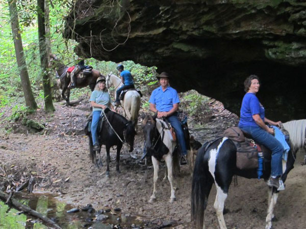 Equitrekking.com - Full Article
October 7, 2015
Wild weather didn’t stop Susan St. Amand from having fun at Big South Fork Recreation Area as part of Equitrekking’s 50 State Trail Riding Project.
by Susan St. Amand
About Big South Fork Recreation Area
Big South Fork Recreation Area is located on the Northeastern end of Tennessee, straddling the Tennessee and Kentucky state lines, turning into the Daniel Boone National Forest on the Kentucky end. It is located between Oneida, Tennessee via Route 297 and Jamestown, Tennessee via Route 154. The Big South Fork Recreation Area is comprised of 120,000 acres and over 212 miles of horseback riding trails.
Our group entered from the east side of Big South Fork from Oneida. This route entails going through “the Gorge” which involves hairpin turns going up and/or down to enter the Big South Fork Recreation area. Caution--slow speeds and good working truck and trailer brakes are essential to maneuver this area...
Read more here:
http://www.equitrekking.com/articles/entry/trail-riding-at-big-south-fork-recreation-area-in-tennessee/?mc_cid=07911f088b&mc_eid=290b655fe3
Wednesday, October 14, 2015
A trail runner defends his right to public lands
HCN.org - Full Article
Ethan Linck
OPINION
Oct. 7, 2015
One September morning, with huckleberry bushes burning a fierce red against a dusting of snow on the banks of the upper Nisqually River, I left Mount Rainier National Park headquarters on a pilgrimage.
Twenty-seven hours later, depleted but filled with a near-religious sense of reverence and elation I've rarely felt since, I arrived back where I'd begun. I'd completely circumnavigated Washington's great mountain on foot, running the entire Wonderland Trail. This route is something of a crown jewel to backpackers, who typically plan on taking 5-to-10 days to cover its 93 miles and 22,000 feet of elevation gain.
Perhaps understandably, the idea of running the length of that trail in a single day can be baffling to people. How could anyone, they ask, possibly appreciate such a majestic environment while running? Was I simply, as Marjorie "Slim" Woodruff put it recently in an opinion piece for Writers on the Range, an "extreme (athlete) seeking ultimate bragging rights?" I'll argue that I'm not, and that trail running is about far more than physical achievement.
I have been a backpacker and day hiker all my life, and in my day job as a biologist I cherish the particular variety of experiences that moving slowly or staying in one place provide. There's the opportunity to allow wildlife to come to you, and the meditative way layers of meaning unravel the longer you stare at something from a particular vantage point. But trail running provides unique rewards. As a way of experiencing nature and landscapes, it has as much depth and resonance as hiking.
As I ran around Mount Rainier, hour following hour, I found myself focused on the changing intricacies of topography and geology. I found myself better able to understand the mountain's majestic scale, and the broad patterning of different habitats splayed across its flanks. And because I spent an entire night moving in complete solitude, I experienced things I never experienced as a hiker. I saw the gleam of the mountain's great icecap growing and then receding as a full moon tracked across the sky, and was treated to the indescribably eerie sound of elk bugling on both sides of me as I moved quietly through a herd.
During the run, I packed out the remains of all the food I brought with me. This should not be surprising as it has been the norm in all the outdoor communities I've been a part of, but as the sport has grown, some hikers have expressed concern new runners fail to follow leave-no-trace principles. Unfortunately, this is not restricted to trail running. Not far from Mount Rainier, in the Enchantments Wilderness, backpackers have left alpine lakeshores strewn with toilet paper, candy bar wrappers, and trampled vegetation. Here, as in the Grand Canyon and other overused areas, education and smart policy – rather than vilification against trail runners – is surely a better approach.
I can't help but think that some of the recent outflow of animosity towards trail runners reflects the latest iteration of misunderstanding between different recreational user groups. This is a conflict as old as our system of public lands itself...
Read more here:
http://www.hcn.org/articles/anger-against-trail-runners-public-lands-Mt-Rainier-Wonderland-Grand-Canyon-response?utm_source=wcn1&utm_medium=email
Monday, October 12, 2015
America’s lands should stay in America’s hands
Thehill.com - Full Article
By Whit Fosburgh
In his Oct. 6 blog post, “A local approach to our public lands,” Rep. Chris Stewart (R-Utah) wrote that “not only can states manage public lands, they can do it for less money and with better results” and that wildfire management, grazing allocations, and energy policy would all be running smoothly, if only the states were in charge.
While I can’t defend every action of the federal government, the notion that our federal lands would be better managed by individual states is fundamentally flawed.
America’s public lands system was developed more than 100 years ago by leading conservationists, like Theodore Roosevelt, who witnessed the destruction of our lands and waters in an unsustainable system of unregulated mining, overgrazing, and overcutting. They acted to create a national system of public lands that could be utilized for the benefit of the American public for generations to come.
America’s 438 million public acres of National Forest and Bureau of Land Management lands are managed under the principles of multiple-use and sustained yield. Under a multiple-use mandate, public lands must be managed for many different uses, including energy and fiber production, outdoor recreation, and habitat improvement, so as to best meet the needs of the American people. Sustained yield requires that resources taken from those lands be done in a sustainable manner, so as not to deplete the resource over time. It doesn’t matter if you are an off-road vehicle enthusiast from Utah, a birdwatcher from Wyoming, or a rancher whose cattle grazes public lands in Montana, this system finds a place for all of us.
By calling for the handover of federal lands and their management to individual states, Stewart and his allies are essentially calling for an end to the sustainable management of our public lands, and a return to the 19th century approach of short-term profiteering at the expense of the American people. Here’s why: All of the Western states require in their constitutions that state lands be managed to maximize profit. Under this model, lands that can’t produce maximum coal, timber, energy, or grazing leases are sold off to the highest bidder...
Read more here:
http://thehill.com/blogs/congress-blog/energy-environment/256263-americas-lands-should-stay-in-americas-hands
Tuesday, October 6, 2015
Featured Nat'l Recreation Trail: Weiser River NR Trail, Idaho
 Americantrails.org - Full Article
The 85-mile rail trail between Weiser and New Meadows passes through desert canyons, evergreen forests, alpine meadows, and small towns. Highlights of the trail are the historic trestles and abundant wildlife.
In August 1997, the Union Pacific Railroad executed a deed granting Friends of the Weiser River Trail the entire rail corridor under the 1983 Railbanking Act. It should be noted that this action placed Friends in the three percent category of rail-trails nationwide that are owned and managed by a private non-profit organization.
From that date forward Friends began the development of the trail; installing access control gates, placing planking and installing 8,100 feet of handrails on the 62 trestles, filing in washouts, grading and rolling the trail and placing various signs showing directions and distances. A weed spraying program is ongoing and includes the annual trek of 1,000 goats along the trail to keep noxious weeds under control.
Transportation enhancement grants have funded pavement and trailheads with informational kiosks in the cities of Weiser, Cambridge and Council. Grants provided under the Recreational Trails Program administered by the Idaho Dept. of Parks and Recreation have funded trestle improvements and trail repairs...
Read more here:
http://www.americantrails.org/nationalrecreationtrails/trailNRT/Weiser-River-Rail-Trail-ID.html
Saturday, October 3, 2015
Featured Nat'l Recreation Trail: Rogue River NRT, Oregon
 Americantrails.org
Featured National Recreation Trails
Hosted by AmericanTrails.org
Every kind of trail activity is represented in the listing of designated NRTs. Besides hiking and bicycling, the system includes water trails, motorized routes, snow tracks, greenways, and equestrian paths. The NRT program showcases the diversity of trails across America, from our cities and suburbs to the deserts, waterways, and high mountains.
Rogue River National Recreation Trail, Oregon
Photos courtesy of Mike Bullington
The Rogue River Trail traverses the wild section of the Rogue National Wild and Scenic River along its entire length, offering scenic landscapes and opportunities for hiking and backpacking.
The Rogue River National Recreation Trail runs 40 miles along the Rogue National Wild and Scenic River in southwestern Oregon. The route offers a variety of amazing landscapes and rewarding hiking experiences.
In addition, the western 16 miles cross the Wild Rogue Wilderness. These national designations recognize and help protect the Rogue’s outstanding scenery, fisheries, and recreational resources for present and future generations. The trail and the river are co-managed by the Bureau of Land Management’s Medford District and the US Forest Service’s Rogue River-Siskiyou National Forest.
The Salem, OR Statesman Journal describes the setting: “The mountains encase the valley in thousand-foot walls, and the river glides deep and green past wildlife, forest, and a civilization of rustic lodges built beginning in the 1930s.”
The Rogue River Trail is managed for hiking and backpacking only. Most of the trail is well constructed and has moderate grades. The average hiker takes 4-5 days to walk the 40 miles.
The trail may be hiked from either end or from the middle. During the heat of the summer when temperatures may reach 100 F, many choose to hike from west to east, keeping the afternoon sun at their backs. Moderate temperatures make spring and fall popular seasons to hike.
Downed trees, landslides and high water in creeks can create difficult passage during the rainy season, usually November through April. Annual maintenance usually occurs April through June, after winter storms are no longer a threat.
Backpackers will find a number of campgrounds along the way. Many campsites are sandy beaches next to the river. These sites may also be used by boaters. Private lodges along the trail can also accommodate hikers who make reservations.
The Rogue River Trail follows the north bank of the river as it winds its way toward the Pacific Ocean. The eastern trailhead is at Grave Creek about 30 miles northwest of the city of Grants Pass. The western trailhead is at Big Bend near Foster Bar, about 35 miles upriver from the coastal town of Gold Beach. The Marial Trailhead and Rogue River Ranch provide access near the midpoint of the trail.
For more information:
http://www.americantrails.org/nationalrecreationtrails/trailNRT/Rogue-River-NRT-OR.html
Friday, October 2, 2015
Congress lets sun set on Land and Water Conservation Fund
HCN.org - Full Article
The nation's most successful conservation program is in jeopardy.
Jodi Peterson
Oct. 1, 2015 Web Exclusive
In July, Montanans celebrated the addition of 8,200 acres, known as Tenderfoot Creek, to the Lewis and Clark National Forest. Most of the $10.7 million cost was paid for by the federal Land and Water Conservation Fund, which uses oil and gas royalties for conservation and recreation projects.
But yesterday, the 50-year-old fund, widely viewed as one of the nation’s most popular and most successful land conservation programs, was allowed to expire completely. Despite broad bipartisan support, and despite a deadline that was no surprise to anyone, Congress failed to take action to reauthorize it. That means that offshore oil and gas producers will no longer be paying into the chest that funds the program — and now that the funding connection has been broken, reinstating it will be very difficult, especially given the tone of this Congress. Instead, lawmakers will be dickering over how to divvy up former LWCF appropriations, which will now be going into the general treasury...
Read more here:
https://www.hcn.org/articles/congress-lets-sun-set-on-land-and-water-conservation-fund
Subscribe to:
Posts (Atom)